Mapping—Here, There, and Everywhere
By Diane M. Calabrese / Published October 2021
Consolidating trips. Avoiding backtracks. Minimizing expenses. All three are familiar activities among sales representatives and service providers.
Much of the basic planning in efficiency is done intuitively. Then, it’s formalized with itineraries and logs. Now, as with most other things, there is an app for all that.
App misleads a bit. A large number of vendors supply mapping solutions for businesses, solutions that deploy sophisticated software to extract the maximum amount of information from the location and type of every sale or prospective sale.

Companies use mapping to do more than gauge sales opportunities and successes. They optimize deliveries and evaluate the best and/or fastest way to ship. They seek out underserved and potential customer areas. And much more…
“We use mapping to put our sales force in an area we want to target by mapping our current customers’ locations and then having our sales force cold-call in the area,” says Jim O’Connell, president of Hotsy Pacific in Modesto, CA. “We set a goal of five to six warm calls on our current customers per day, and then the bulk of the calls are on prospects or potential customers within the same general area.”
The strategy promotes efficiency. “We can keep in touch with our customers as well as direct our sales force where we want them to work, which gives them a weekly schedule to follow,” explains O’Connell.
And does O’Connell recommend any specific program for the type of use his company makes of mapping? “Google Maps and MapQuest seem to work best for our needs,” he says.
Mapping can take finding new customers to a new level. For example, a business can use mapping to better understand the dispersion of its customers and to evaluate markets and prospective markets.
Maptitude, a product of Caliper Corporation in Newton, MA, would even enable a contractor to determine boundaries of a service area that minimize travel and maximize profit, says Stewart Berry, vice president of the corporation. The product is a dynamic one that allows adopters to add data and connect to other corporate resources as well as analyze geographic data.
An expert in geographic information system (GIS) software, Berry encourages readers to visit his
company’s website to get better acquainted with the capabilities of his firm’s products. He also writes and offers freely available blog texts on the use of GIS in customer mapping and beyond.
Berry’s piece “What Is the Best Territory Alignment Software for a Startup?” (https://www.linkedin.com/pulse/what-best-sales-territory-alignment-software-startup-stewart-berry) is one that will interest distributors aiming to establish or realign sales territories and contractors considering satellite operations.
Governments at all levels have used GIS for decades. The city of Charlotte, NC, claims to be one of
the first municipalities to implement GIS, which it did in 1983.
Charlotte has a GIS department and maintains more than 140 data layers currently. Citizens and employees of the town alike can use the repository.
City-level GIS repositories can be very useful and cost-free to tap. For contractors who want to know the density of single-family homes or income level of an area, they are an excellent resource.
To quickly check state and local GIS databases, search USA.gov for GIS and the specific area of interest. Distributors and manufacturers can use the databases to assess how many competitors or colleagues they have in an area.
Federal entities from FEMA to NASA make significant use of GIS. The U.S. Geological Survey is the primary source of GIS data. USGS offerings such as The National Map and Earth Explorer are derived from it.
Since 2001, the USGS has offered the open-access tool GloVis (GloVis.gov), which stands for Global Visualization Viewer. Registration is required for use, but the registrant gains access to images as well as navigation tools. For anyone in our industry trying to get an accurate view of the lay of the land for a new location or a new facility, it’s a good place to start.
Off the record, we spoke to members of our industry who had a bit of hesitation about using mapping to better understand and serve their customers. They wondered if there were a line that might be crossed ethically with too much information about the customer in hand.
In reality, the line was crossed some time ago. [The most recent Google Map of this writer’s house includes a little sign that reads ‘Free Plants” and a tray of extra seedlings.]
And about that line, to be more accurate, there has always been a sort of informal way of assessing the layers—from terrain and population density to income and size of structures. Sales representatives observed people and places and formed ideas about how to serve them. Now, with mapping they simply get a technological assist.
What can be done?
The question for contractors, distributors, and manufacturers is whether they should be doing more with mapping. Let’s consider some possibilities.
Benchmarking, which is one of the benefits to members of CETA [Cleaning Equipment Trade Association], allows companies to evaluate their performance by (anonymous) comparison with colleagues. Information obtained can be coupled with mapping to provide even more insight into direction to take for improvement.
A sales representative who seems to be closing less frequently than other reps may have a more difficult trek in terms of geography. Mapping allows an owner to assign routes so that each representative has a minimum of travel and a maximum of person-to-person time.
Mapping can also facilitate pairing of team members at locations where a customized solution is in the works without having either team member pulled away too long from other priorities. In other words, it can be used as a scheduling tool to minimize disruption to other projects.
Designing sales territories to produce the most sales with the smallest team benefits the company and each sales representative. Sellers have always worked to strike the optimal design. With mapping software it’s much easier.
In addition, it’s possible to verify that a particular design is best by overlaying sales with territory configuration. Try one design for three months and another for three months, then compare.
If one part of a territory yields more sales than others, a business owner can use mapping to assess what—if anything—is unique about it. For a manufacturer, it may be that distributors there are supplying many contractors serving high-end gated, golf, or condominium communities. The contractors are larger, have abundant work, and require more equipment and parts.
Perhaps fewer visits to part of a territory where sales are less frequent in exchange for more calls in an area like the one where sales are high makes sense. Mapping enables a manufacturer to find such a territory.
Contractors can use mapping to be sure the territory they serve will not stretch them too thin. With fuel prices increasing—and the possibility that miles traveled will be taxed in some states—traveling less and pressure washing more should be the goal. Mapping to identify dense pockets of customers who are most likely to require and be able to pay for services is the place to begin.
Mapping returns on ad investments also minimizes business expenses. A contractor may be paying for a digital ad to pop up whenever a person living within the service area does a search for pressure washing. But service areas vary greatly in income level. If ads are targeted to high-end parts of the area, where customers are more likely to contract for cleaning, it may bring in more paying prospects.
With the many layers of data available in mapping software, a manufacturer, distributor, or contractor can define sales or service routes in a way that extracts the most profit for the investment. Manufacturers can also use mapping to analyze the feasibility of building a warehouse or a new plant at a site.
Everything from traffic patterns to characteristics of the area can be mapped. Is a property truly commercial, or is there a residential community nearby that will not be welcoming? What is the tax structure in the area, and are taxes promised for the manufacturer’s property commensurate with similarly sized properties?
The sophistication of mapping software cannot be overstated. Sales representatives have long had “tickler files,” or notes about each customer’s preferences and approach to making buying decisions (e.g., deliberative, impulsive). Such profiles can be used to create territories.
Perhaps one sales representative works better with the customer who ruminates before every decision, and another representative understands the impulse buyer. A company with a big enough customer base can sort to match customer temperament and sales representative approach.
Trends are of perennial interest to every business owner. With mapping they can be identified early. A sudden dip in service calls from a once-thriving segment of a contractor’s territory must be explored. It could be a competitor is on the ground and working outside legal parameters.
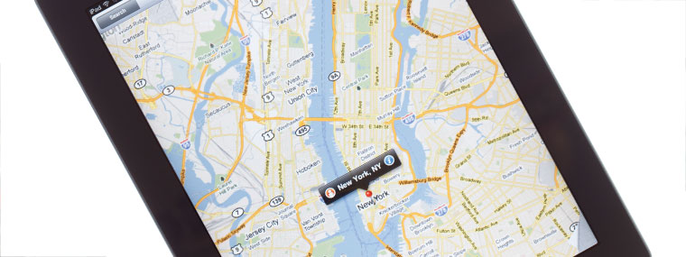
Think of mapping as an exceedingly accurate portrayal of information. It provides a high-resolution picture of what and where. A business owner can say, I am here and there is where I need to be.

Current Digital Issue
|
|
Click to read.
|


Go Mobile